Very basic script sample on how to generate a KML file.

A Trowel, I haz one
A Trowel, I haz one
A very young version of me, running around with a trowel. I’m very excited about the trowel.
Posted on Flickr 4:22 pm, April 30, 2008
Dented Reality
My personal/professional website.
twistori
Really cool social experiment based on tracking keywords on Twitter.
AB Meta @ AdaptiveBlue
“AB Meta is a simple and open format for annotating pages that are about things.”
Matewatch: Time tacker for TextMate
Matewatch: Time tacker for TextMate
A pretty nifty little application/script that monitors how long you have files open in TM so that you can bill more accurately for your time (freelancing etc).

Post Krav Grading
Post Krav Grading
I was looking pretty good after the 6+ hour grading for Level 2 – Level 3.
Posted on Flickr 7:02 am, April 29, 2008
Muxtape
Cool site that allows you to create your own mp3 mix-tapes and share them easily online.
Pentax DSmobile 600 Scanner @ Amazon
Pentax DSmobile 600 Scanner @ Amazon
Perfect portable scanner for acquiring documents while on the move.
jQuery Autocomplete
Implementation of a JS autocompletion script using jQuery. Nice and clean.
Reset styles
A couple of examples of CSS Reset files to get you started on common ground.

Distant Bridge
Distant Bridge
We rented kayaks at Rose Bay and kayaked around the point to get a snack.
Posted on Flickr 4:26 pm, April 10, 2008 jQuery(document).ready(function(){ var gmap_m4bf01a2db3102e2d52a3a0bf53175a2f = { positions : { 31 : new google.maps.LatLng( ‘-33.874548’, ‘151.261997’ ) }, bounds : new google.maps.LatLngBounds(), // empty for now, we’ll dynamically extend it later map : new google.maps.Map( document.getElementById( ‘gmap_m4bf01a2db3102e2d52a3a0bf53175a2f’ ), { mapTypeId: google.maps.MapTypeId.ROADMAP, center: new google.maps.LatLng( 0, 0 ), zoom: 16 // Seems to be a good zoom for a single point } ), markers : {}, }; // end of gmap // Extend the bounds of interest based on our positions for ( var m in gmap_m4bf01a2db3102e2d52a3a0bf53175a2f.positions ) { gmap_m4bf01a2db3102e2d52a3a0bf53175a2f.bounds.extend( gmap_m4bf01a2db3102e2d52a3a0bf53175a2f.positions[m] ); } // Render markers for ( var m in gmap_m4bf01a2db3102e2d52a3a0bf53175a2f.positions ) { gmap_m4bf01a2db3102e2d52a3a0bf53175a2f.markers[m] = new google.maps.Marker( { clickable: true, map : gmap_m4bf01a2db3102e2d52a3a0bf53175a2f.map, position : gmap_m4bf01a2db3102e2d52a3a0bf53175a2f.positions[m] } ); } // Redraw map to fit our new marker-based bounds gmap_m4bf01a2db3102e2d52a3a0bf53175a2f.map.setCenter( gmap_m4bf01a2db3102e2d52a3a0bf53175a2f.positions[31] ); });

Kai-yaking
Kai-yaking
We rented kayaks at Rose Bay and kayaked around the point to get a snack.
Posted on Flickr 4:25 pm, April 10, 2008 jQuery(document).ready(function(){ var gmap_m349d2456c975965648c98bc6bb05b43b = { positions : { 752 : new google.maps.LatLng( ‘-33.874548’, ‘151.261997’ ) }, bounds : new google.maps.LatLngBounds(), // empty for now, we’ll dynamically extend it later map : new google.maps.Map( document.getElementById( ‘gmap_m349d2456c975965648c98bc6bb05b43b’ ), { mapTypeId: google.maps.MapTypeId.ROADMAP, center: new google.maps.LatLng( 0, 0 ), zoom: 16 // Seems to be a good zoom for a single point } ), markers : {}, }; // end of gmap // Extend the bounds of interest based on our positions for ( var m in gmap_m349d2456c975965648c98bc6bb05b43b.positions ) { gmap_m349d2456c975965648c98bc6bb05b43b.bounds.extend( gmap_m349d2456c975965648c98bc6bb05b43b.positions[m] ); } // Render markers for ( var m in gmap_m349d2456c975965648c98bc6bb05b43b.positions ) { gmap_m349d2456c975965648c98bc6bb05b43b.markers[m] = new google.maps.Marker( { clickable: true, map : gmap_m349d2456c975965648c98bc6bb05b43b.map, position : gmap_m349d2456c975965648c98bc6bb05b43b.positions[m] } ); } // Redraw map to fit our new marker-based bounds gmap_m349d2456c975965648c98bc6bb05b43b.map.setCenter( gmap_m349d2456c975965648c98bc6bb05b43b.positions[752] ); });

Time To Get Going
Time To Get Going
We rented kayaks at Rose Bay and kayaked around the point to get a snack.
Posted on Flickr 4:24 pm, April 10, 2008 jQuery(document).ready(function(){ var gmap_m8cd9906370adbf9ea257c703a482104c = { positions : { 251 : new google.maps.LatLng( ‘-33.874548’, ‘151.261997’ ) }, bounds : new google.maps.LatLngBounds(), // empty for now, we’ll dynamically extend it later map : new google.maps.Map( document.getElementById( ‘gmap_m8cd9906370adbf9ea257c703a482104c’ ), { mapTypeId: google.maps.MapTypeId.ROADMAP, center: new google.maps.LatLng( 0, 0 ), zoom: 16 // Seems to be a good zoom for a single point } ), markers : {}, }; // end of gmap // Extend the bounds of interest based on our positions for ( var m in gmap_m8cd9906370adbf9ea257c703a482104c.positions ) { gmap_m8cd9906370adbf9ea257c703a482104c.bounds.extend( gmap_m8cd9906370adbf9ea257c703a482104c.positions[m] ); } // Render markers for ( var m in gmap_m8cd9906370adbf9ea257c703a482104c.positions ) { gmap_m8cd9906370adbf9ea257c703a482104c.markers[m] = new google.maps.Marker( { clickable: true, map : gmap_m8cd9906370adbf9ea257c703a482104c.map, position : gmap_m8cd9906370adbf9ea257c703a482104c.positions[m] } ); } // Redraw map to fit our new marker-based bounds gmap_m8cd9906370adbf9ea257c703a482104c.map.setCenter( gmap_m8cd9906370adbf9ea257c703a482104c.positions[251] ); });

Brothers
Brothers
Sitting like this I suppose we do look pretty similar, but I still don’t see it in our faces.
Posted on Flickr 3:53 pm, April 10, 2008 jQuery(document).ready(function(){ var gmap_m4c8dcbda2752d1f7a8dd5a740f1a8a4f = { positions : { 711 : new google.maps.LatLng( ‘-33.874548’, ‘151.261997’ ) }, bounds : new google.maps.LatLngBounds(), // empty for now, we’ll dynamically extend it later map : new google.maps.Map( document.getElementById( ‘gmap_m4c8dcbda2752d1f7a8dd5a740f1a8a4f’ ), { mapTypeId: google.maps.MapTypeId.ROADMAP, center: new google.maps.LatLng( 0, 0 ), zoom: 16 // Seems to be a good zoom for a single point } ), markers : {}, }; // end of gmap // Extend the bounds of interest based on our positions for ( var m in gmap_m4c8dcbda2752d1f7a8dd5a740f1a8a4f.positions ) { gmap_m4c8dcbda2752d1f7a8dd5a740f1a8a4f.bounds.extend( gmap_m4c8dcbda2752d1f7a8dd5a740f1a8a4f.positions[m] ); } // Render markers for ( var m in gmap_m4c8dcbda2752d1f7a8dd5a740f1a8a4f.positions ) { gmap_m4c8dcbda2752d1f7a8dd5a740f1a8a4f.markers[m] = new google.maps.Marker( { clickable: true, map : gmap_m4c8dcbda2752d1f7a8dd5a740f1a8a4f.map, position : gmap_m4c8dcbda2752d1f7a8dd5a740f1a8a4f.positions[m] } ); } // Redraw map to fit our new marker-based bounds gmap_m4c8dcbda2752d1f7a8dd5a740f1a8a4f.map.setCenter( gmap_m4c8dcbda2752d1f7a8dd5a740f1a8a4f.positions[711] ); });

The Opera House

Bats
Bats
What’s with all the bats in the Botanical Gardens?
-33.871555151.226291
Posted on Flickr 4:41 pm, April 9, 2008

Getting Back to Nature
Getting Back to Nature
In the Sydney Botanical Gardens
Posted on Flickr 5:51 pm, April 9, 2008 jQuery(document).ready(function(){ var gmap_m88cfe4c45eeec3532eb76452bf67e58d = { positions : { 100 : new google.maps.LatLng( ‘-33.871555’, ‘151.226291’ ) }, bounds : new google.maps.LatLngBounds(), // empty for now, we’ll dynamically extend it later map : new google.maps.Map( document.getElementById( ‘gmap_m88cfe4c45eeec3532eb76452bf67e58d’ ), { mapTypeId: google.maps.MapTypeId.ROADMAP, center: new google.maps.LatLng( 0, 0 ), zoom: 16 // Seems to be a good zoom for a single point } ), markers : {}, }; // end of gmap // Extend the bounds of interest based on our positions for ( var m in gmap_m88cfe4c45eeec3532eb76452bf67e58d.positions ) { gmap_m88cfe4c45eeec3532eb76452bf67e58d.bounds.extend( gmap_m88cfe4c45eeec3532eb76452bf67e58d.positions[m] ); } // Render markers for ( var m in gmap_m88cfe4c45eeec3532eb76452bf67e58d.positions ) { gmap_m88cfe4c45eeec3532eb76452bf67e58d.markers[m] = new google.maps.Marker( { clickable: true, map : gmap_m88cfe4c45eeec3532eb76452bf67e58d.map, position : gmap_m88cfe4c45eeec3532eb76452bf67e58d.positions[m] } ); } // Redraw map to fit our new marker-based bounds gmap_m88cfe4c45eeec3532eb76452bf67e58d.map.setCenter( gmap_m88cfe4c45eeec3532eb76452bf67e58d.positions[100] ); });

Bamboo!
Bamboo!
I <3 Bamboo
Posted on Flickr 4:50 pm, April 9, 2008 jQuery(document).ready(function(){ var gmap_m2fb17a1b1930f64446564b67afadf24a = { positions : { 612 : new google.maps.LatLng( ‘-33.871555’, ‘151.226291’ ) }, bounds : new google.maps.LatLngBounds(), // empty for now, we’ll dynamically extend it later map : new google.maps.Map( document.getElementById( ‘gmap_m2fb17a1b1930f64446564b67afadf24a’ ), { mapTypeId: google.maps.MapTypeId.ROADMAP, center: new google.maps.LatLng( 0, 0 ), zoom: 16 // Seems to be a good zoom for a single point } ), markers : {}, }; // end of gmap // Extend the bounds of interest based on our positions for ( var m in gmap_m2fb17a1b1930f64446564b67afadf24a.positions ) { gmap_m2fb17a1b1930f64446564b67afadf24a.bounds.extend( gmap_m2fb17a1b1930f64446564b67afadf24a.positions[m] ); } // Render markers for ( var m in gmap_m2fb17a1b1930f64446564b67afadf24a.positions ) { gmap_m2fb17a1b1930f64446564b67afadf24a.markers[m] = new google.maps.Marker( { clickable: true, map : gmap_m2fb17a1b1930f64446564b67afadf24a.map, position : gmap_m2fb17a1b1930f64446564b67afadf24a.positions[m] } ); } // Redraw map to fit our new marker-based bounds gmap_m2fb17a1b1930f64446564b67afadf24a.map.setCenter( gmap_m2fb17a1b1930f64446564b67afadf24a.positions[612] ); });

Bats
Bats
What’s with all the bats in the Botanical Gardens?
Posted on Flickr 4:38 pm, April 9, 2008 jQuery(document).ready(function(){ var gmap_m7f0915a135c99e808956482ee713dd20 = { positions : { 763 : new google.maps.LatLng( ‘-33.871555’, ‘151.226291’ ) }, bounds : new google.maps.LatLngBounds(), // empty for now, we’ll dynamically extend it later map : new google.maps.Map( document.getElementById( ‘gmap_m7f0915a135c99e808956482ee713dd20’ ), { mapTypeId: google.maps.MapTypeId.ROADMAP, center: new google.maps.LatLng( 0, 0 ), zoom: 16 // Seems to be a good zoom for a single point } ), markers : {}, }; // end of gmap // Extend the bounds of interest based on our positions for ( var m in gmap_m7f0915a135c99e808956482ee713dd20.positions ) { gmap_m7f0915a135c99e808956482ee713dd20.bounds.extend( gmap_m7f0915a135c99e808956482ee713dd20.positions[m] ); } // Render markers for ( var m in gmap_m7f0915a135c99e808956482ee713dd20.positions ) { gmap_m7f0915a135c99e808956482ee713dd20.markers[m] = new google.maps.Marker( { clickable: true, map : gmap_m7f0915a135c99e808956482ee713dd20.map, position : gmap_m7f0915a135c99e808956482ee713dd20.positions[m] } ); } // Redraw map to fit our new marker-based bounds gmap_m7f0915a135c99e808956482ee713dd20.map.setCenter( gmap_m7f0915a135c99e808956482ee713dd20.positions[763] ); });

Open Limit
Open Limit
This road sign means “no enforced speed limit, drive as fast as you can safely”
Posted on Flickr 2:00 pm, April 8, 2008

Dad and Me
Dad and Me
The morning we left from Bremer Bay.
Posted on Flickr 1:08 pm, April 8, 2008 jQuery(document).ready(function(){ var gmap_m09db43ffef6d4d7b8623f50aa3cc00be = { positions : { 627 : new google.maps.LatLng( ‘-34.397703’, ‘119.387397’ ) }, bounds : new google.maps.LatLngBounds(), // empty for now, we’ll dynamically extend it later map : new google.maps.Map( document.getElementById( ‘gmap_m09db43ffef6d4d7b8623f50aa3cc00be’ ), { mapTypeId: google.maps.MapTypeId.ROADMAP, center: new google.maps.LatLng( 0, 0 ), zoom: 16 // Seems to be a good zoom for a single point } ), markers : {}, }; // end of gmap // Extend the bounds of interest based on our positions for ( var m in gmap_m09db43ffef6d4d7b8623f50aa3cc00be.positions ) { gmap_m09db43ffef6d4d7b8623f50aa3cc00be.bounds.extend( gmap_m09db43ffef6d4d7b8623f50aa3cc00be.positions[m] ); } // Render markers for ( var m in gmap_m09db43ffef6d4d7b8623f50aa3cc00be.positions ) { gmap_m09db43ffef6d4d7b8623f50aa3cc00be.markers[m] = new google.maps.Marker( { clickable: true, map : gmap_m09db43ffef6d4d7b8623f50aa3cc00be.map, position : gmap_m09db43ffef6d4d7b8623f50aa3cc00be.positions[m] } ); } // Redraw map to fit our new marker-based bounds gmap_m09db43ffef6d4d7b8623f50aa3cc00be.map.setCenter( gmap_m09db43ffef6d4d7b8623f50aa3cc00be.positions[627] ); });


Tiger Snake
Tiger Snake
Driving around near Bremer is like being on a safari, you just pull over to see the wildlife. This was a pretty big one – a couple meters long.
-34.36859119.322681
Posted on Flickr 3:38 pm, April 7, 2008 jQuery(document).ready(function(){ var gmap_m8d19de24119ba50e89566e83682ac162 = { positions : { 122 : new google.maps.LatLng( ‘-34.36859’, ‘119.322681’ ) }, bounds : new google.maps.LatLngBounds(), // empty for now, we’ll dynamically extend it later map : new google.maps.Map( document.getElementById( ‘gmap_m8d19de24119ba50e89566e83682ac162’ ), { mapTypeId: google.maps.MapTypeId.ROADMAP, center: new google.maps.LatLng( 0, 0 ), zoom: 16 // Seems to be a good zoom for a single point } ), markers : {}, }; // end of gmap // Extend the bounds of interest based on our positions for ( var m in gmap_m8d19de24119ba50e89566e83682ac162.positions ) { gmap_m8d19de24119ba50e89566e83682ac162.bounds.extend( gmap_m8d19de24119ba50e89566e83682ac162.positions[m] ); } // Render markers for ( var m in gmap_m8d19de24119ba50e89566e83682ac162.positions ) { gmap_m8d19de24119ba50e89566e83682ac162.markers[m] = new google.maps.Marker( { clickable: true, map : gmap_m8d19de24119ba50e89566e83682ac162.map, position : gmap_m8d19de24119ba50e89566e83682ac162.positions[m] } ); } // Redraw map to fit our new marker-based bounds gmap_m8d19de24119ba50e89566e83682ac162.map.setCenter( gmap_m8d19de24119ba50e89566e83682ac162.positions[122] ); });

Royal Hakea
Royal Hakea
Bizarre plant only found in the Fitzgerald River National Park, next door to Bremer Bay
Posted on Flickr 4:14 pm, April 7, 2008 jQuery(document).ready(function(){ var gmap_m6409120e71e12bab7575a7373489538b = { positions : { 690 : new google.maps.LatLng( ‘-34.36859’, ‘119.322681’ ) }, bounds : new google.maps.LatLngBounds(), // empty for now, we’ll dynamically extend it later map : new google.maps.Map( document.getElementById( ‘gmap_m6409120e71e12bab7575a7373489538b’ ), { mapTypeId: google.maps.MapTypeId.ROADMAP, center: new google.maps.LatLng( 0, 0 ), zoom: 16 // Seems to be a good zoom for a single point } ), markers : {}, }; // end of gmap // Extend the bounds of interest based on our positions for ( var m in gmap_m6409120e71e12bab7575a7373489538b.positions ) { gmap_m6409120e71e12bab7575a7373489538b.bounds.extend( gmap_m6409120e71e12bab7575a7373489538b.positions[m] ); } // Render markers for ( var m in gmap_m6409120e71e12bab7575a7373489538b.positions ) { gmap_m6409120e71e12bab7575a7373489538b.markers[m] = new google.maps.Marker( { clickable: true, map : gmap_m6409120e71e12bab7575a7373489538b.map, position : gmap_m6409120e71e12bab7575a7373489538b.positions[m] } ); } // Redraw map to fit our new marker-based bounds gmap_m6409120e71e12bab7575a7373489538b.map.setCenter( gmap_m6409120e71e12bab7575a7373489538b.positions[690] ); });

River Gorge
River Gorge
Posted on Flickr 3:52 pm, April 7, 2008 jQuery(document).ready(function(){ var gmap_ma1543f249ffad38a00cc7f68ed9b8bf5 = { positions : { 173 : new google.maps.LatLng( ‘-34.36859’, ‘119.322681’ ) }, bounds : new google.maps.LatLngBounds(), // empty for now, we’ll dynamically extend it later map : new google.maps.Map( document.getElementById( ‘gmap_ma1543f249ffad38a00cc7f68ed9b8bf5’ ), { mapTypeId: google.maps.MapTypeId.ROADMAP, center: new google.maps.LatLng( 0, 0 ), zoom: 16 // Seems to be a good zoom for a single point } ), markers : {}, }; // end of gmap // Extend the bounds of interest based on our positions for ( var m in gmap_ma1543f249ffad38a00cc7f68ed9b8bf5.positions ) { gmap_ma1543f249ffad38a00cc7f68ed9b8bf5.bounds.extend( gmap_ma1543f249ffad38a00cc7f68ed9b8bf5.positions[m] ); } // Render markers for ( var m in gmap_ma1543f249ffad38a00cc7f68ed9b8bf5.positions ) { gmap_ma1543f249ffad38a00cc7f68ed9b8bf5.markers[m] = new google.maps.Marker( { clickable: true, map : gmap_ma1543f249ffad38a00cc7f68ed9b8bf5.map, position : gmap_ma1543f249ffad38a00cc7f68ed9b8bf5.positions[m] } ); } // Redraw map to fit our new marker-based bounds gmap_ma1543f249ffad38a00cc7f68ed9b8bf5.map.setCenter( gmap_ma1543f249ffad38a00cc7f68ed9b8bf5.positions[173] ); });

Fisheries Marina @ Bremer Bay
Fisheries Marina @ Bremer Bay
-34.481231119.373493
Posted on Flickr 6:04 pm, April 6, 2008 jQuery(document).ready(function(){ var gmap_ma45fe32f3a089aab20b7d3a85cb77f2d = { positions : { 925 : new google.maps.LatLng( ‘-34.481231’, ‘119.373493’ ) }, bounds : new google.maps.LatLngBounds(), // empty for now, we’ll dynamically extend it later map : new google.maps.Map( document.getElementById( ‘gmap_ma45fe32f3a089aab20b7d3a85cb77f2d’ ), { mapTypeId: google.maps.MapTypeId.ROADMAP, center: new google.maps.LatLng( 0, 0 ), zoom: 16 // Seems to be a good zoom for a single point } ), markers : {}, }; // end of gmap // Extend the bounds of interest based on our positions for ( var m in gmap_ma45fe32f3a089aab20b7d3a85cb77f2d.positions ) { gmap_ma45fe32f3a089aab20b7d3a85cb77f2d.bounds.extend( gmap_ma45fe32f3a089aab20b7d3a85cb77f2d.positions[m] ); } // Render markers for ( var m in gmap_ma45fe32f3a089aab20b7d3a85cb77f2d.positions ) { gmap_ma45fe32f3a089aab20b7d3a85cb77f2d.markers[m] = new google.maps.Marker( { clickable: true, map : gmap_ma45fe32f3a089aab20b7d3a85cb77f2d.map, position : gmap_ma45fe32f3a089aab20b7d3a85cb77f2d.positions[m] } ); } // Redraw map to fit our new marker-based bounds gmap_ma45fe32f3a089aab20b7d3a85cb77f2d.map.setCenter( gmap_ma45fe32f3a089aab20b7d3a85cb77f2d.positions[925] ); });

House on a Hill
House on a Hill
Very mediterranean-looking.
Posted on Flickr 6:42 pm, April 6, 2008 jQuery(document).ready(function(){ var gmap_m5d05bf31cf6d028ad971d8646f570e0e = { positions : { 241 : new google.maps.LatLng( ‘-34.45696’, ‘119.365425’ ) }, bounds : new google.maps.LatLngBounds(), // empty for now, we’ll dynamically extend it later map : new google.maps.Map( document.getElementById( ‘gmap_m5d05bf31cf6d028ad971d8646f570e0e’ ), { mapTypeId: google.maps.MapTypeId.ROADMAP, center: new google.maps.LatLng( 0, 0 ), zoom: 16 // Seems to be a good zoom for a single point } ), markers : {}, }; // end of gmap // Extend the bounds of interest based on our positions for ( var m in gmap_m5d05bf31cf6d028ad971d8646f570e0e.positions ) { gmap_m5d05bf31cf6d028ad971d8646f570e0e.bounds.extend( gmap_m5d05bf31cf6d028ad971d8646f570e0e.positions[m] ); } // Render markers for ( var m in gmap_m5d05bf31cf6d028ad971d8646f570e0e.positions ) { gmap_m5d05bf31cf6d028ad971d8646f570e0e.markers[m] = new google.maps.Marker( { clickable: true, map : gmap_m5d05bf31cf6d028ad971d8646f570e0e.map, position : gmap_m5d05bf31cf6d028ad971d8646f570e0e.positions[m] } ); } // Redraw map to fit our new marker-based bounds gmap_m5d05bf31cf6d028ad971d8646f570e0e.map.setCenter( gmap_m5d05bf31cf6d028ad971d8646f570e0e.positions[241] ); });

“The Church”
“The Church”
A really strange “house” being built in Bremer Bay overlooking the ocean.
Posted on Flickr 6:42 pm, April 6, 2008 jQuery(document).ready(function(){ var gmap_m43141027dc1576292b1c56c637d5243d = { positions : { 418 : new google.maps.LatLng( ‘-34.45696’, ‘119.365425’ ) }, bounds : new google.maps.LatLngBounds(), // empty for now, we’ll dynamically extend it later map : new google.maps.Map( document.getElementById( ‘gmap_m43141027dc1576292b1c56c637d5243d’ ), { mapTypeId: google.maps.MapTypeId.ROADMAP, center: new google.maps.LatLng( 0, 0 ), zoom: 16 // Seems to be a good zoom for a single point } ), markers : {}, }; // end of gmap // Extend the bounds of interest based on our positions for ( var m in gmap_m43141027dc1576292b1c56c637d5243d.positions ) { gmap_m43141027dc1576292b1c56c637d5243d.bounds.extend( gmap_m43141027dc1576292b1c56c637d5243d.positions[m] ); } // Render markers for ( var m in gmap_m43141027dc1576292b1c56c637d5243d.positions ) { gmap_m43141027dc1576292b1c56c637d5243d.markers[m] = new google.maps.Marker( { clickable: true, map : gmap_m43141027dc1576292b1c56c637d5243d.map, position : gmap_m43141027dc1576292b1c56c637d5243d.positions[m] } ); } // Redraw map to fit our new marker-based bounds gmap_m43141027dc1576292b1c56c637d5243d.map.setCenter( gmap_m43141027dc1576292b1c56c637d5243d.positions[418] ); });


More Roos Near Karma Chalets
More Roos Near Karma Chalets
Posted on Flickr 1:34 pm, April 6, 2008 jQuery(document).ready(function(){ var gmap_m974fcb8f514174d25a044f92dd333c66 = { positions : { 439 : new google.maps.LatLng( ‘-34.983877’, ‘117.298278’ ) }, bounds : new google.maps.LatLngBounds(), // empty for now, we’ll dynamically extend it later map : new google.maps.Map( document.getElementById( ‘gmap_m974fcb8f514174d25a044f92dd333c66’ ), { mapTypeId: google.maps.MapTypeId.ROADMAP, center: new google.maps.LatLng( 0, 0 ), zoom: 16 // Seems to be a good zoom for a single point } ), markers : {}, }; // end of gmap // Extend the bounds of interest based on our positions for ( var m in gmap_m974fcb8f514174d25a044f92dd333c66.positions ) { gmap_m974fcb8f514174d25a044f92dd333c66.bounds.extend( gmap_m974fcb8f514174d25a044f92dd333c66.positions[m] ); } // Render markers for ( var m in gmap_m974fcb8f514174d25a044f92dd333c66.positions ) { gmap_m974fcb8f514174d25a044f92dd333c66.markers[m] = new google.maps.Marker( { clickable: true, map : gmap_m974fcb8f514174d25a044f92dd333c66.map, position : gmap_m974fcb8f514174d25a044f92dd333c66.positions[m] } ); } // Redraw map to fit our new marker-based bounds gmap_m974fcb8f514174d25a044f92dd333c66.map.setCenter( gmap_m974fcb8f514174d25a044f92dd333c66.positions[439] ); });

Me & The Ladies
Me & The Ladies
-34.983877117.298278
Posted on Flickr 12:37 am, April 6, 2008 jQuery(document).ready(function(){ var gmap_m35a907cf12b9ee5bc424f1f034d3c933 = { positions : { 553 : new google.maps.LatLng( ‘-34.983877’, ‘117.298278’ ) }, bounds : new google.maps.LatLngBounds(), // empty for now, we’ll dynamically extend it later map : new google.maps.Map( document.getElementById( ‘gmap_m35a907cf12b9ee5bc424f1f034d3c933’ ), { mapTypeId: google.maps.MapTypeId.ROADMAP, center: new google.maps.LatLng( 0, 0 ), zoom: 16 // Seems to be a good zoom for a single point } ), markers : {}, }; // end of gmap // Extend the bounds of interest based on our positions for ( var m in gmap_m35a907cf12b9ee5bc424f1f034d3c933.positions ) { gmap_m35a907cf12b9ee5bc424f1f034d3c933.bounds.extend( gmap_m35a907cf12b9ee5bc424f1f034d3c933.positions[m] ); } // Render markers for ( var m in gmap_m35a907cf12b9ee5bc424f1f034d3c933.positions ) { gmap_m35a907cf12b9ee5bc424f1f034d3c933.markers[m] = new google.maps.Marker( { clickable: true, map : gmap_m35a907cf12b9ee5bc424f1f034d3c933.map, position : gmap_m35a907cf12b9ee5bc424f1f034d3c933.positions[m] } ); } // Redraw map to fit our new marker-based bounds gmap_m35a907cf12b9ee5bc424f1f034d3c933.map.setCenter( gmap_m35a907cf12b9ee5bc424f1f034d3c933.positions[553] ); });

The Denmark Maze
The Denmark Maze
-34.983877117.298278
Posted on Flickr 6:21 pm, April 5, 2008 jQuery(document).ready(function(){ var gmap_m77b4a4cd74fa557ae835e924c3cbacc7 = { positions : { 303 : new google.maps.LatLng( ‘-34.983877’, ‘117.298278’ ) }, bounds : new google.maps.LatLngBounds(), // empty for now, we’ll dynamically extend it later map : new google.maps.Map( document.getElementById( ‘gmap_m77b4a4cd74fa557ae835e924c3cbacc7’ ), { mapTypeId: google.maps.MapTypeId.ROADMAP, center: new google.maps.LatLng( 0, 0 ), zoom: 16 // Seems to be a good zoom for a single point } ), markers : {}, }; // end of gmap // Extend the bounds of interest based on our positions for ( var m in gmap_m77b4a4cd74fa557ae835e924c3cbacc7.positions ) { gmap_m77b4a4cd74fa557ae835e924c3cbacc7.bounds.extend( gmap_m77b4a4cd74fa557ae835e924c3cbacc7.positions[m] ); } // Render markers for ( var m in gmap_m77b4a4cd74fa557ae835e924c3cbacc7.positions ) { gmap_m77b4a4cd74fa557ae835e924c3cbacc7.markers[m] = new google.maps.Marker( { clickable: true, map : gmap_m77b4a4cd74fa557ae835e924c3cbacc7.map, position : gmap_m77b4a4cd74fa557ae835e924c3cbacc7.positions[m] } ); } // Redraw map to fit our new marker-based bounds gmap_m77b4a4cd74fa557ae835e924c3cbacc7.map.setCenter( gmap_m77b4a4cd74fa557ae835e924c3cbacc7.positions[303] ); });

Tree-cover
Tree-cover
Posted on Flickr 6:32 pm, April 5, 2008 jQuery(document).ready(function(){ var gmap_mc1cbb4838e5651a4ef9206f7e7790d66 = { positions : { 631 : new google.maps.LatLng( ‘-34.983877’, ‘117.298278’ ) }, bounds : new google.maps.LatLngBounds(), // empty for now, we’ll dynamically extend it later map : new google.maps.Map( document.getElementById( ‘gmap_mc1cbb4838e5651a4ef9206f7e7790d66’ ), { mapTypeId: google.maps.MapTypeId.ROADMAP, center: new google.maps.LatLng( 0, 0 ), zoom: 16 // Seems to be a good zoom for a single point } ), markers : {}, }; // end of gmap // Extend the bounds of interest based on our positions for ( var m in gmap_mc1cbb4838e5651a4ef9206f7e7790d66.positions ) { gmap_mc1cbb4838e5651a4ef9206f7e7790d66.bounds.extend( gmap_mc1cbb4838e5651a4ef9206f7e7790d66.positions[m] ); } // Render markers for ( var m in gmap_mc1cbb4838e5651a4ef9206f7e7790d66.positions ) { gmap_mc1cbb4838e5651a4ef9206f7e7790d66.markers[m] = new google.maps.Marker( { clickable: true, map : gmap_mc1cbb4838e5651a4ef9206f7e7790d66.map, position : gmap_mc1cbb4838e5651a4ef9206f7e7790d66.positions[m] } ); } // Redraw map to fit our new marker-based bounds gmap_mc1cbb4838e5651a4ef9206f7e7790d66.map.setCenter( gmap_mc1cbb4838e5651a4ef9206f7e7790d66.positions[631] ); });

Green’s Pool
Green’s Pool
Posted on Flickr 5:52 pm, April 5, 2008 jQuery(document).ready(function(){ var gmap_m9a8ee6934536fb70af1d03180dcf5975 = { positions : { 831 : new google.maps.LatLng( ‘-34.983877’, ‘117.298278’ ) }, bounds : new google.maps.LatLngBounds(), // empty for now, we’ll dynamically extend it later map : new google.maps.Map( document.getElementById( ‘gmap_m9a8ee6934536fb70af1d03180dcf5975’ ), { mapTypeId: google.maps.MapTypeId.ROADMAP, center: new google.maps.LatLng( 0, 0 ), zoom: 16 // Seems to be a good zoom for a single point } ), markers : {}, }; // end of gmap // Extend the bounds of interest based on our positions for ( var m in gmap_m9a8ee6934536fb70af1d03180dcf5975.positions ) { gmap_m9a8ee6934536fb70af1d03180dcf5975.bounds.extend( gmap_m9a8ee6934536fb70af1d03180dcf5975.positions[m] ); } // Render markers for ( var m in gmap_m9a8ee6934536fb70af1d03180dcf5975.positions ) { gmap_m9a8ee6934536fb70af1d03180dcf5975.markers[m] = new google.maps.Marker( { clickable: true, map : gmap_m9a8ee6934536fb70af1d03180dcf5975.map, position : gmap_m9a8ee6934536fb70af1d03180dcf5975.positions[m] } ); } // Redraw map to fit our new marker-based bounds gmap_m9a8ee6934536fb70af1d03180dcf5975.map.setCenter( gmap_m9a8ee6934536fb70af1d03180dcf5975.positions[831] ); });

Tim, Shanthi and Me
Tim, Shanthi and Me
-34.983877117.298278
- #australia
- #beau
- #beaulebens
- #foresthillwinery
- #me
- #renniewedding
- #shanthi
- #tim
- #timswedding
- #westernaustraliadenmark
Posted on Flickr 2:58 am, April 5, 2008 jQuery(document).ready(function(){ var gmap_m39cfef96a5cfd3065c1267d05c59d721 = { positions : { 44 : new google.maps.LatLng( ‘-34.983877’, ‘117.298278’ ) }, bounds : new google.maps.LatLngBounds(), // empty for now, we’ll dynamically extend it later map : new google.maps.Map( document.getElementById( ‘gmap_m39cfef96a5cfd3065c1267d05c59d721’ ), { mapTypeId: google.maps.MapTypeId.ROADMAP, center: new google.maps.LatLng( 0, 0 ), zoom: 16 // Seems to be a good zoom for a single point } ), markers : {}, }; // end of gmap // Extend the bounds of interest based on our positions for ( var m in gmap_m39cfef96a5cfd3065c1267d05c59d721.positions ) { gmap_m39cfef96a5cfd3065c1267d05c59d721.bounds.extend( gmap_m39cfef96a5cfd3065c1267d05c59d721.positions[m] ); } // Render markers for ( var m in gmap_m39cfef96a5cfd3065c1267d05c59d721.positions ) { gmap_m39cfef96a5cfd3065c1267d05c59d721.markers[m] = new google.maps.Marker( { clickable: true, map : gmap_m39cfef96a5cfd3065c1267d05c59d721.map, position : gmap_m39cfef96a5cfd3065c1267d05c59d721.positions[m] } ); } // Redraw map to fit our new marker-based bounds gmap_m39cfef96a5cfd3065c1267d05c59d721.map.setCenter( gmap_m39cfef96a5cfd3065c1267d05c59d721.positions[44] ); });

100_1622
100_1622
-34.983877117.298278
Posted on Flickr 2:58 am, April 5, 2008 jQuery(document).ready(function(){ var gmap_mdba6f063bc222c8262b3cc2192cef8ba = { positions : { 619 : new google.maps.LatLng( ‘-34.983877’, ‘117.298278’ ) }, bounds : new google.maps.LatLngBounds(), // empty for now, we’ll dynamically extend it later map : new google.maps.Map( document.getElementById( ‘gmap_mdba6f063bc222c8262b3cc2192cef8ba’ ), { mapTypeId: google.maps.MapTypeId.ROADMAP, center: new google.maps.LatLng( 0, 0 ), zoom: 16 // Seems to be a good zoom for a single point } ), markers : {}, }; // end of gmap // Extend the bounds of interest based on our positions for ( var m in gmap_mdba6f063bc222c8262b3cc2192cef8ba.positions ) { gmap_mdba6f063bc222c8262b3cc2192cef8ba.bounds.extend( gmap_mdba6f063bc222c8262b3cc2192cef8ba.positions[m] ); } // Render markers for ( var m in gmap_mdba6f063bc222c8262b3cc2192cef8ba.positions ) { gmap_mdba6f063bc222c8262b3cc2192cef8ba.markers[m] = new google.maps.Marker( { clickable: true, map : gmap_mdba6f063bc222c8262b3cc2192cef8ba.map, position : gmap_mdba6f063bc222c8262b3cc2192cef8ba.positions[m] } ); } // Redraw map to fit our new marker-based bounds gmap_mdba6f063bc222c8262b3cc2192cef8ba.map.setCenter( gmap_mdba6f063bc222c8262b3cc2192cef8ba.positions[619] ); });

100_1617
100_1617
-34.983877117.298278
Posted on Flickr 2:55 am, April 5, 2008 jQuery(document).ready(function(){ var gmap_m0326f132902c2a1f689fb7b24371f2e3 = { positions : { 526 : new google.maps.LatLng( ‘-34.983877’, ‘117.298278’ ) }, bounds : new google.maps.LatLngBounds(), // empty for now, we’ll dynamically extend it later map : new google.maps.Map( document.getElementById( ‘gmap_m0326f132902c2a1f689fb7b24371f2e3’ ), { mapTypeId: google.maps.MapTypeId.ROADMAP, center: new google.maps.LatLng( 0, 0 ), zoom: 16 // Seems to be a good zoom for a single point } ), markers : {}, }; // end of gmap // Extend the bounds of interest based on our positions for ( var m in gmap_m0326f132902c2a1f689fb7b24371f2e3.positions ) { gmap_m0326f132902c2a1f689fb7b24371f2e3.bounds.extend( gmap_m0326f132902c2a1f689fb7b24371f2e3.positions[m] ); } // Render markers for ( var m in gmap_m0326f132902c2a1f689fb7b24371f2e3.positions ) { gmap_m0326f132902c2a1f689fb7b24371f2e3.markers[m] = new google.maps.Marker( { clickable: true, map : gmap_m0326f132902c2a1f689fb7b24371f2e3.map, position : gmap_m0326f132902c2a1f689fb7b24371f2e3.positions[m] } ); } // Redraw map to fit our new marker-based bounds gmap_m0326f132902c2a1f689fb7b24371f2e3.map.setCenter( gmap_m0326f132902c2a1f689fb7b24371f2e3.positions[526] ); });

Lone Tree in the Dark
Lone Tree in the Dark
As viewed from the balcony at Forest-Hill Winery. I believe this was Tim’s idea – top work son!
-34.983877117.298278
Posted on Flickr 2:51 am, April 5, 2008 jQuery(document).ready(function(){ var gmap_mfc7748ff370f3800f9d253271e940076 = { positions : { 360 : new google.maps.LatLng( ‘-34.983877’, ‘117.298278’ ) }, bounds : new google.maps.LatLngBounds(), // empty for now, we’ll dynamically extend it later map : new google.maps.Map( document.getElementById( ‘gmap_mfc7748ff370f3800f9d253271e940076’ ), { mapTypeId: google.maps.MapTypeId.ROADMAP, center: new google.maps.LatLng( 0, 0 ), zoom: 16 // Seems to be a good zoom for a single point } ), markers : {}, }; // end of gmap // Extend the bounds of interest based on our positions for ( var m in gmap_mfc7748ff370f3800f9d253271e940076.positions ) { gmap_mfc7748ff370f3800f9d253271e940076.bounds.extend( gmap_mfc7748ff370f3800f9d253271e940076.positions[m] ); } // Render markers for ( var m in gmap_mfc7748ff370f3800f9d253271e940076.positions ) { gmap_mfc7748ff370f3800f9d253271e940076.markers[m] = new google.maps.Marker( { clickable: true, map : gmap_mfc7748ff370f3800f9d253271e940076.map, position : gmap_mfc7748ff370f3800f9d253271e940076.positions[m] } ); } // Redraw map to fit our new marker-based bounds gmap_mfc7748ff370f3800f9d253271e940076.map.setCenter( gmap_mfc7748ff370f3800f9d253271e940076.positions[360] ); });

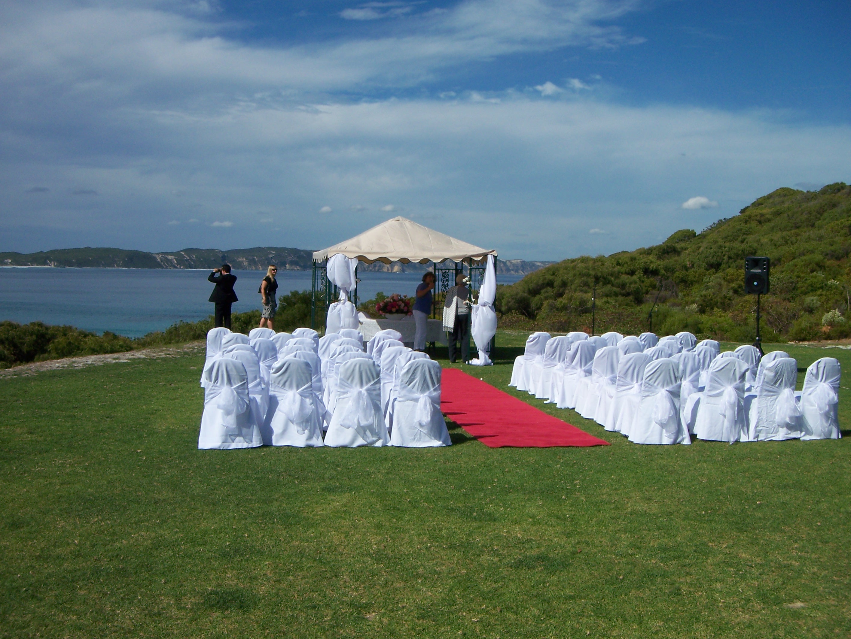
The Ceremony

The Ceremony

The Boys

Set Up

Beach Tennis
Beach Tennis
How do other people celebrate getting married?
Posted on Flickr 10:43 pm, April 4, 2008 jQuery(document).ready(function(){ var gmap_m2cc8aa1b25352f53775de373a84f075c = { positions : { 35 : new google.maps.LatLng( ‘-34.983877’, ‘117.298278’ ) }, bounds : new google.maps.LatLngBounds(), // empty for now, we’ll dynamically extend it later map : new google.maps.Map( document.getElementById( ‘gmap_m2cc8aa1b25352f53775de373a84f075c’ ), { mapTypeId: google.maps.MapTypeId.ROADMAP, center: new google.maps.LatLng( 0, 0 ), zoom: 16 // Seems to be a good zoom for a single point } ), markers : {}, }; // end of gmap // Extend the bounds of interest based on our positions for ( var m in gmap_m2cc8aa1b25352f53775de373a84f075c.positions ) { gmap_m2cc8aa1b25352f53775de373a84f075c.bounds.extend( gmap_m2cc8aa1b25352f53775de373a84f075c.positions[m] ); } // Render markers for ( var m in gmap_m2cc8aa1b25352f53775de373a84f075c.positions ) { gmap_m2cc8aa1b25352f53775de373a84f075c.markers[m] = new google.maps.Marker( { clickable: true, map : gmap_m2cc8aa1b25352f53775de373a84f075c.map, position : gmap_m2cc8aa1b25352f53775de373a84f075c.positions[m] } ); } // Redraw map to fit our new marker-based bounds gmap_m2cc8aa1b25352f53775de373a84f075c.map.setCenter( gmap_m2cc8aa1b25352f53775de373a84f075c.positions[35] ); });

Bright Coast
Bright Coast
Posted on Flickr 9:49 pm, April 4, 2008 jQuery(document).ready(function(){ var gmap_mdc785dd7b63ca285360f30b2242816e5 = { positions : { 965 : new google.maps.LatLng( ‘-34.983877’, ‘117.298278’ ) }, bounds : new google.maps.LatLngBounds(), // empty for now, we’ll dynamically extend it later map : new google.maps.Map( document.getElementById( ‘gmap_mdc785dd7b63ca285360f30b2242816e5’ ), { mapTypeId: google.maps.MapTypeId.ROADMAP, center: new google.maps.LatLng( 0, 0 ), zoom: 16 // Seems to be a good zoom for a single point } ), markers : {}, }; // end of gmap // Extend the bounds of interest based on our positions for ( var m in gmap_mdc785dd7b63ca285360f30b2242816e5.positions ) { gmap_mdc785dd7b63ca285360f30b2242816e5.bounds.extend( gmap_mdc785dd7b63ca285360f30b2242816e5.positions[m] ); } // Render markers for ( var m in gmap_mdc785dd7b63ca285360f30b2242816e5.positions ) { gmap_mdc785dd7b63ca285360f30b2242816e5.markers[m] = new google.maps.Marker( { clickable: true, map : gmap_mdc785dd7b63ca285360f30b2242816e5.map, position : gmap_mdc785dd7b63ca285360f30b2242816e5.positions[m] } ); } // Redraw map to fit our new marker-based bounds gmap_mdc785dd7b63ca285360f30b2242816e5.map.setCenter( gmap_mdc785dd7b63ca285360f30b2242816e5.positions[965] ); });

Descent
Descent
Down to the beach to take wedding photos!
Posted on Flickr 9:49 pm, April 4, 2008 jQuery(document).ready(function(){ var gmap_md237c4d0eb248a19e49a82b0ac89bfcd = { positions : { 970 : new google.maps.LatLng( ‘-35.03604’, ‘117.329177’ ) }, bounds : new google.maps.LatLngBounds(), // empty for now, we’ll dynamically extend it later map : new google.maps.Map( document.getElementById( ‘gmap_md237c4d0eb248a19e49a82b0ac89bfcd’ ), { mapTypeId: google.maps.MapTypeId.ROADMAP, center: new google.maps.LatLng( 0, 0 ), zoom: 16 // Seems to be a good zoom for a single point } ), markers : {}, }; // end of gmap // Extend the bounds of interest based on our positions for ( var m in gmap_md237c4d0eb248a19e49a82b0ac89bfcd.positions ) { gmap_md237c4d0eb248a19e49a82b0ac89bfcd.bounds.extend( gmap_md237c4d0eb248a19e49a82b0ac89bfcd.positions[m] ); } // Render markers for ( var m in gmap_md237c4d0eb248a19e49a82b0ac89bfcd.positions ) { gmap_md237c4d0eb248a19e49a82b0ac89bfcd.markers[m] = new google.maps.Marker( { clickable: true, map : gmap_md237c4d0eb248a19e49a82b0ac89bfcd.map, position : gmap_md237c4d0eb248a19e49a82b0ac89bfcd.positions[m] } ); } // Redraw map to fit our new marker-based bounds gmap_md237c4d0eb248a19e49a82b0ac89bfcd.map.setCenter( gmap_md237c4d0eb248a19e49a82b0ac89bfcd.positions[970] ); });

Australian Bride
Australian Bride
I love this photo, I think it really captures the casual-yet-classy, down-to-earth wedding that they had. Rock out MA.
- #australia
- #barefoot
- #beer
- #bride
- #glasses
- #maryann
- #renniewedding
- #sunnies
- #timswedding
- #westernaustraliadenmark
Posted on Flickr 9:42 pm, April 4, 2008 jQuery(document).ready(function(){ var gmap_m0afbaedab273e8c16c55f0c1fda8ac35 = { positions : { 663 : new google.maps.LatLng( ‘-35.03604’, ‘117.329177’ ) }, bounds : new google.maps.LatLngBounds(), // empty for now, we’ll dynamically extend it later map : new google.maps.Map( document.getElementById( ‘gmap_m0afbaedab273e8c16c55f0c1fda8ac35’ ), { mapTypeId: google.maps.MapTypeId.ROADMAP, center: new google.maps.LatLng( 0, 0 ), zoom: 16 // Seems to be a good zoom for a single point } ), markers : {}, }; // end of gmap // Extend the bounds of interest based on our positions for ( var m in gmap_m0afbaedab273e8c16c55f0c1fda8ac35.positions ) { gmap_m0afbaedab273e8c16c55f0c1fda8ac35.bounds.extend( gmap_m0afbaedab273e8c16c55f0c1fda8ac35.positions[m] ); } // Render markers for ( var m in gmap_m0afbaedab273e8c16c55f0c1fda8ac35.positions ) { gmap_m0afbaedab273e8c16c55f0c1fda8ac35.markers[m] = new google.maps.Marker( { clickable: true, map : gmap_m0afbaedab273e8c16c55f0c1fda8ac35.map, position : gmap_m0afbaedab273e8c16c55f0c1fda8ac35.positions[m] } ); } // Redraw map to fit our new marker-based bounds gmap_m0afbaedab273e8c16c55f0c1fda8ac35.map.setCenter( gmap_m0afbaedab273e8c16c55f0c1fda8ac35.positions[663] ); });

The Ceremony
The Ceremony
Posted on Flickr 8:28 pm, April 4, 2008 jQuery(document).ready(function(){ var gmap_mdc51d5589e5e0014a29a198b2ed6a7ca = { positions : { 602 : new google.maps.LatLng( ‘-35.03604’, ‘117.329177’ ) }, bounds : new google.maps.LatLngBounds(), // empty for now, we’ll dynamically extend it later map : new google.maps.Map( document.getElementById( ‘gmap_mdc51d5589e5e0014a29a198b2ed6a7ca’ ), { mapTypeId: google.maps.MapTypeId.ROADMAP, center: new google.maps.LatLng( 0, 0 ), zoom: 16 // Seems to be a good zoom for a single point } ), markers : {}, }; // end of gmap // Extend the bounds of interest based on our positions for ( var m in gmap_mdc51d5589e5e0014a29a198b2ed6a7ca.positions ) { gmap_mdc51d5589e5e0014a29a198b2ed6a7ca.bounds.extend( gmap_mdc51d5589e5e0014a29a198b2ed6a7ca.positions[m] ); } // Render markers for ( var m in gmap_mdc51d5589e5e0014a29a198b2ed6a7ca.positions ) { gmap_mdc51d5589e5e0014a29a198b2ed6a7ca.markers[m] = new google.maps.Marker( { clickable: true, map : gmap_mdc51d5589e5e0014a29a198b2ed6a7ca.map, position : gmap_mdc51d5589e5e0014a29a198b2ed6a7ca.positions[m] } ); } // Redraw map to fit our new marker-based bounds gmap_mdc51d5589e5e0014a29a198b2ed6a7ca.map.setCenter( gmap_mdc51d5589e5e0014a29a198b2ed6a7ca.positions[602] ); });

Ocean Beach
Ocean Beach
At Denmark.
Posted on Flickr 3:04 pm, April 4, 2008 jQuery(document).ready(function(){ var gmap_m10582b1270bdc33a575d7c1ce4d4eaa0 = { positions : { 863 : new google.maps.LatLng( ‘-35.03604’, ‘117.329177’ ) }, bounds : new google.maps.LatLngBounds(), // empty for now, we’ll dynamically extend it later map : new google.maps.Map( document.getElementById( ‘gmap_m10582b1270bdc33a575d7c1ce4d4eaa0’ ), { mapTypeId: google.maps.MapTypeId.ROADMAP, center: new google.maps.LatLng( 0, 0 ), zoom: 16 // Seems to be a good zoom for a single point } ), markers : {}, }; // end of gmap // Extend the bounds of interest based on our positions for ( var m in gmap_m10582b1270bdc33a575d7c1ce4d4eaa0.positions ) { gmap_m10582b1270bdc33a575d7c1ce4d4eaa0.bounds.extend( gmap_m10582b1270bdc33a575d7c1ce4d4eaa0.positions[m] ); } // Render markers for ( var m in gmap_m10582b1270bdc33a575d7c1ce4d4eaa0.positions ) { gmap_m10582b1270bdc33a575d7c1ce4d4eaa0.markers[m] = new google.maps.Marker( { clickable: true, map : gmap_m10582b1270bdc33a575d7c1ce4d4eaa0.map, position : gmap_m10582b1270bdc33a575d7c1ce4d4eaa0.positions[m] } ); } // Redraw map to fit our new marker-based bounds gmap_m10582b1270bdc33a575d7c1ce4d4eaa0.map.setCenter( gmap_m10582b1270bdc33a575d7c1ce4d4eaa0.positions[863] ); });

View
View
This is what we saw from the balcony (or our window) at Karma Chalets. Not bad at all.
Posted on Flickr 11:22 pm, April 3, 2008


Cottesloe Beach

Search Analytics: Site search analytics workshop slides
Search Analytics: Site search analytics workshop slides
Presentation on site search analytics and how to implement them, why they’re useful etc.


The Australian Odyssey: SFO-AUK
We were hungry, but we were ready, so we decided to just go to the airport and eat there. Airplane food tends to be horrible, but airport food is normally at least bearable. On the train heading to SFO, an incredible example of a hipster geek presented itself. We counted the following “authority indicators” testifying to his most definite geekiness. The first 5 were immediately obvious, but then he just kept pulling things out during his 10-minute ride:
(more…)
Coolamon on a Magpie?
Coolamon on a Magpie?
I spent a few hours walking around Auckland since I had a 9-hour layover.
Posted on Flickr 9:04 am, March 28, 2008

Gate to the Park
Gate to the Park
I spent a few hours walking around Auckland since I had a 9-hour layover.
Posted on Flickr 8:34 am, March 28, 2008

Auckland Civic Theatre
Auckland Civic Theatre
I spent a few hours walking around Auckland since I had a 9-hour layover.
Posted on Flickr 8:29 am, March 28, 2008

Auckland SkyTower
Auckland SkyTower
I spent a few hours walking around Auckland since I had a 9-hour layover.
Posted on Flickr 8:19 am, March 28, 2008

Shipping Machines in Auckland
Shipping Machines in Auckland
I spent a few hours walking around Auckland since I had a 9-hour layover.
Posted on Flickr 7:38 am, March 28, 2008

Ship in Auckland
Ship in Auckland
I spent a few hours walking around Auckland since I had a 9-hour layover.
Posted on Flickr 7:32 am, March 28, 2008
The Twenty-Five Most Valuable Blogs
The Twenty-Five Most Valuable Blogs
Very interesting financial analysis of the value of the bigger blogs out there.