
Checked in at WaterCourse Foods .
First time here! — with Kelly

Good work on the sunset, Denver. #nofilter
Posted on Instagram 5:24 pm, January 25, 2018 jQuery(document).ready(function(){ var gmap_mf9d734f768d4d956a489d5c4078f2620 = { positions : { 441 : new google.maps.LatLng( ‘39.7675084’, ‘-104.9740488’ ) }, bounds : new google.maps.LatLngBounds(), // empty for now, we’ll dynamically extend it later map : new google.maps.Map( document.getElementById( ‘gmap_mf9d734f768d4d956a489d5c4078f2620’ ), { mapTypeId: google.maps.MapTypeId.ROADMAP, center: new google.maps.LatLng( 0, 0 ), zoom: 16 // Seems to be a good zoom for a single point } ), markers : {}, }; // end of gmap // Extend the bounds of interest based on our positions for ( var m in gmap_mf9d734f768d4d956a489d5c4078f2620.positions ) { gmap_mf9d734f768d4d956a489d5c4078f2620.bounds.extend( gmap_mf9d734f768d4d956a489d5c4078f2620.positions[m] ); } // Render markers for ( var m in gmap_mf9d734f768d4d956a489d5c4078f2620.positions ) { gmap_mf9d734f768d4d956a489d5c4078f2620.markers[m] = new google.maps.Marker( { clickable: true, map : gmap_mf9d734f768d4d956a489d5c4078f2620.map, position : gmap_mf9d734f768d4d956a489d5c4078f2620.positions[m] } ); } // Redraw map to fit our new marker-based bounds gmap_mf9d734f768d4d956a489d5c4078f2620.map.setCenter( gmap_mf9d734f768d4d956a489d5c4078f2620.positions[441] ); });
Imagining a Better Online – Internet Law and Ethics 101 – Medium

Credit: Lightcome/iStock via Getty Images Plus
“Everything is about to change. The world is going to crack wide open.”
Those are the final words from a character on Halt and Catch Fire, AMC’s series about the dawn of Silicon Valley and the digital age. It’s the late 1980s, and the character (we won’t spoil who it is) had just leaped to their death rather than face prison time for computer crimes, leaving behind a suicide note, a profound voiceover from beyond the grave explaining their motive and, in doing so, predicting The Internet As We Know It:
(more…)Is Your Team Too Big? Too Small? What’s the Right Number? – Knowledge@Wharton

When it comes to athletics, sports teams have a specific number of team players: A basketball team needs five, baseball nine, and soccer 11. But when it comes to the workplace, where teamwork is increasingly widespread throughout complex and expanding organizations, there is no hard-and-fast rule to determine the optimal number to have on each team.
(more…)How to Start Thinking Like a Data Scientist
Slowly but steadily, data are forcing their way into every nook and cranny of every industry, company, and job. Managers who aren’t data savvy, who can’t conduct basic analyses, interpret more complex ones, and interact with data scientists are already at a disadvantage. Companies without a large and growing cadre of data-savvy managers are similarly disadvantaged.
Fortunately, you don’t have to be a data scientist or a Bayesian statistician to tease useful insights from data. This post explores an exercise I’ve used for 20 years to help those with an open mind (and a pencil, paper, and calculator) get started. One post won’t make you data savvy, but it will help you become data literate, open your eyes to the millions of small data opportunities, and enable you work a bit more effectively with data scientists, analytics, and all things quantitative.
(more…)Big Data’s Biggest Challenge? Convincing People NOT to Trust Their Judgment
Here’s a simple rule for the second machine age we’re in now: as the amount of data goes up, the importance of human judgment should go down.
The previous statement reads like heresy, doesn’t it? Management education today is largely about educating for judgment —developing future leaders’ pattern-matching abilities, usually via exposure to a lot of case studies and other examples, so that they’ll be able to confidently navigate the business landscape. And whether or not we’re in b-school, we’re told to trust our guts and instincts, and that (especially after we gain experience) we can make accurate assessments in a blink .
(more…)An Introduction to Data-Driven Decisions for Managers Who Don’t Like Math
Not a week goes by without us publishing something here at HBR about the value of data in business. Big data, small data, internal, external, experimental, observational — everywhere we look, information is being captured, quantified, and used to make business decisions.
Not everyone needs to become a quant. But it is worth brushing up on the basics of quantitative analysis, so as to understand and improve the use of data in your business. We’ve created a reading list of the best HBR articles on the subject to get you started.
(more…)Checked in at Star Kitchen .
Dim sum! — with erika
Jean Hsu on people-centric management – Inside Intercom
When it comes to the importance of good people management, one data point speaks loudly above the rest. That is, people leave managers not companies.
Yet the transition from individual contributor to first-time manager is never easy, and there’s no perfect playbook. Engineering leadership coach Jean Hsu is on a mission to bridge that gap.
Following stints at Google, Pulse and most recently Medium, Jean works with technical leads through workshops and 1:1 coaching to help them get the most from their team beyond the immediate product cycle or feature release. She’s frequently writing about leadership on her blog , and just recently announced a new project with fellow engineering leader Edmond Lau , which you can learn more about here .
(more…)
I travel a fair bit for work, and have historically let it affect (read: completely stop) any sort of fitness routine I might have going at home. Normally I try to get to the gym 2-3 times a week, and do whatever is the WOD at my CrossFit (Sprint) gym. When traveling, I just let it slide normally, and then try to get back into a routine when I get home.
(more…)Checked in at Schebens Manor .
Home for reals
Checked in at RTD – Denver Airport Station .
When your manager isn’t supporting you, build a Voltron
In my years of coaching managers and individual contributors, I’ve routinely heard the following complaints about their bosses:
It can feel tremendously frustrating to expect a particular kind of support of your manager, and have them fail to deliver it, or even acknowledge it. In my own career, I’ve had plenty of manager bad-fits: folks who were good executors but not good at managing people, folks who gave me little-to-no constructive feedback (more on this phenomenon ), folks who prioritized supporting their peers over supporting their team.
(more…)Checked in at Denver International Airport (DEN) .
Ice on the road. Rear wheel drive. Broken TV. No space for carry on. It’s all happening this morning.
Checked in at Red Rocks Park & Amphitheatre .
with erika

Snowshoeing near Coppper.
Posted on Instagram 10:21 am, December 31, 2017 jQuery(document).ready(function(){ var gmap_md704a959ceb96a283e0e1f33210cf25f = { positions : { 923 : new google.maps.LatLng( ‘39.500861’, ‘-106.1535167’ ) }, bounds : new google.maps.LatLngBounds(), // empty for now, we’ll dynamically extend it later map : new google.maps.Map( document.getElementById( ‘gmap_md704a959ceb96a283e0e1f33210cf25f’ ), { mapTypeId: google.maps.MapTypeId.ROADMAP, center: new google.maps.LatLng( 0, 0 ), zoom: 16 // Seems to be a good zoom for a single point } ), markers : {}, }; // end of gmap // Extend the bounds of interest based on our positions for ( var m in gmap_md704a959ceb96a283e0e1f33210cf25f.positions ) { gmap_md704a959ceb96a283e0e1f33210cf25f.bounds.extend( gmap_md704a959ceb96a283e0e1f33210cf25f.positions[m] ); } // Render markers for ( var m in gmap_md704a959ceb96a283e0e1f33210cf25f.positions ) { gmap_md704a959ceb96a283e0e1f33210cf25f.markers[m] = new google.maps.Marker( { clickable: true, map : gmap_md704a959ceb96a283e0e1f33210cf25f.map, position : gmap_md704a959ceb96a283e0e1f33210cf25f.positions[m] } ); } // Redraw map to fit our new marker-based bounds gmap_md704a959ceb96a283e0e1f33210cf25f.map.setCenter( gmap_md704a959ceb96a283e0e1f33210cf25f.positions[923] ); });
Checked in at Denver Wrangler .
Nightcap + pool — with erika
Checked in at The Home Depot .
Bambi’s first Home Depot adventure.

Christmas Eve dinner was spectacular, thanks to @akires
Posted on Instagram 9:40 am, December 26, 2017

Best elements in the table!
Posted on Instagram 9:27 am, December 16, 2017 jQuery(document).ready(function(){ var gmap_m917b5c4c719ab68997513c4b6aaf0670 = { positions : { 502 : new google.maps.LatLng( ‘39.760328348259’, ‘-105.02221113277’ ) }, bounds : new google.maps.LatLngBounds(), // empty for now, we’ll dynamically extend it later map : new google.maps.Map( document.getElementById( ‘gmap_m917b5c4c719ab68997513c4b6aaf0670’ ), { mapTypeId: google.maps.MapTypeId.ROADMAP, center: new google.maps.LatLng( 0, 0 ), zoom: 16 // Seems to be a good zoom for a single point } ), markers : {}, }; // end of gmap // Extend the bounds of interest based on our positions for ( var m in gmap_m917b5c4c719ab68997513c4b6aaf0670.positions ) { gmap_m917b5c4c719ab68997513c4b6aaf0670.bounds.extend( gmap_m917b5c4c719ab68997513c4b6aaf0670.positions[m] ); } // Render markers for ( var m in gmap_m917b5c4c719ab68997513c4b6aaf0670.positions ) { gmap_m917b5c4c719ab68997513c4b6aaf0670.markers[m] = new google.maps.Marker( { clickable: true, map : gmap_m917b5c4c719ab68997513c4b6aaf0670.map, position : gmap_m917b5c4c719ab68997513c4b6aaf0670.positions[m] } ); } // Redraw map to fit our new marker-based bounds gmap_m917b5c4c719ab68997513c4b6aaf0670.map.setCenter( gmap_m917b5c4c719ab68997513c4b6aaf0670.positions[502] ); });
Checked in at Denver North High School .
Giving out holiday boxes — with erika
Checked in at Enterprise 5280 .
39.761625-104.97923
Launch is the beginning – The Year of the Looking Glass – Medium
This was first published on my mailing list The Looking Glass . Every week, I answer a reader’s question.

Photo by Glenn Beltz
Q: My team is about to launch a major new feature in our software. I’ve been working on this since I joined the company six month ago, so this is my first time shipping a product. I’m excited to bring my work to the world, but also worried it will fail. What advice can you share on how approach a launch?
(more…)01 Dec 2017
In my five years as a VC, I’ve worked closely with the founders of 50+ companies. Many of these companies have grown headcount substantially since I first met them. One of the biggest challenges that founders and early employees face is scaling up personally to meet the ever-growing needs of a business. People sometimes gets stuck and become bottlenecks because they are reluctant to delegate the things they are great at, or they don’t want their role to include new tasks that arise as a company grows. As executive coach Marshall Goldsmith says, “what got you here won’t get you there .”
(more…)For the past four years, we’ve done scrum the same way. Standing up at 9am sharp.
Our scrum is straightforward. What were you working on yesterday? What are you working on today? Are there any changes to plans or intersecting efforts that should be discussed?
When we were small, this worked great. As we grew, we needed to tighten up our scrum updates to keep scrum an efficient use of everyone’s time. Then our web and mobile teams started participating in a combined scrum so we had to make our updates even more concise. Around this time we also made a decision to save any tangents or questions for after scrum to make sure we weren’t wasting a large portion of the team’s time while two engineers went into the weeds on something.
(more…)


Rad light show at the #blossomsoflight show last night.
jQuery(document).ready(function(){ var gmap_m2d4fc2c2ea49f14f154e89ddd2c7d323 = { positions : { 962 : new google.maps.LatLng( ‘39.73214416473’, ‘-104.9607721189’ ) }, bounds : new google.maps.LatLngBounds(), // empty for now, we’ll dynamically extend it later map : new google.maps.Map( document.getElementById( ‘gmap_m2d4fc2c2ea49f14f154e89ddd2c7d323’ ), { mapTypeId: google.maps.MapTypeId.ROADMAP, center: new google.maps.LatLng( 0, 0 ), zoom: 16 // Seems to be a good zoom for a single point } ), markers : {}, }; // end of gmap // Extend the bounds of interest based on our positions for ( var m in gmap_m2d4fc2c2ea49f14f154e89ddd2c7d323.positions ) { gmap_m2d4fc2c2ea49f14f154e89ddd2c7d323.bounds.extend( gmap_m2d4fc2c2ea49f14f154e89ddd2c7d323.positions[m] ); } // Render markers for ( var m in gmap_m2d4fc2c2ea49f14f154e89ddd2c7d323.positions ) { gmap_m2d4fc2c2ea49f14f154e89ddd2c7d323.markers[m] = new google.maps.Marker( { clickable: true, map : gmap_m2d4fc2c2ea49f14f154e89ddd2c7d323.map, position : gmap_m2d4fc2c2ea49f14f154e89ddd2c7d323.positions[m] } ); } // Redraw map to fit our new marker-based bounds gmap_m2d4fc2c2ea49f14f154e89ddd2c7d323.map.setCenter( gmap_m2d4fc2c2ea49f14f154e89ddd2c7d323.positions[962] ); });


Yesterday, I received my new iPhone X. I thought I’d post some notes on the painful process that has been switching over to it. Might be time to start experimenting with a Pixel .
I’m on the Apple Upgrade program , so I assumed it would be a relatively simple process to get bumped up to the next phone, since it’s been more than a year since I got the iPhone 7 Plus. Instead, it ended up involving talking to multiple different people at the Apple store before I could figure out how it all worked, and how to get a new phone, even though my current phone had a cracked screen. Their online eligibility check kept saying that I had used my allotted AppleCare instances, even though I’ve never used any. Eventually I found out that I need to just tell their system there’s nothing wrong with my phone, and then when I send it back in, I’ll end up being asked to pay the $29 to fix the screen, and then they’ll accept is as a trade-in. OK, fine.
(more…)Why a Flat Organizational Structure will Fail as You Grow
A few years ago, having a flat organizational structure was all the rage. Well-known companies like Zappos, Medium, and Buffer were singing its praises and writing detailed posts explaining their reasoning.
Tired of bad bosses, and corporate politics, the internet rejoiced.
On paper it sounded so great. Why do we need managers? Who needs structure? We’re all adults here, right?!?
(more…)Checked in at Nashville International Airport (BNA) .
Time to jet back home already.

Checked in at WordCamp US 2017 .
@ctaylor talking about the next phase of growth for WordPress at #wcus
36.157781-86.777524
Box’s VP Engineering on Biohacks For A Better Career
Tomas Barreto , VP of Engineering at Box , takes biohacking seriously. Like sequencing-his-genome, running-currents-through-his-body seriously.
But don’t call it a hobby or a side project. Barreto draws a straight line between the biohacking work he’s done to not only a more thoughtful, healthier life but also the trajectory of his career. It’s brought him longevity and increasing responsibility at Box, where he’s been promoted five times, starting as a software engineer to his current role as VP of Engineering. He credits biohacking for giving him resilience and capacity, both of which he needed in spades to grow his subset of the engineering team from 5 to 130, from its early days through a high-profile IPO.
(more…)
Illustration by mikoto
3 out of 5 people are either mismatched or mis-qualified for the tasks they are doing during the day. Did I just make up this statistic? A little bit. But it is probably not far off the mark.
Finding the right task for someone is not a simple process. A problem should not be too easy or hard. It has to be interesting to the individual. There has to be meaning. The team needs to work well together. As we can see there are lots of things to consider when matching someone to a task. But why is this important?
(more…)7 Steps to Learning from Our Mistakes
Here a sailor loads a torpedo. Even when operations don’t have glaring problems, an assessment can reveal areas for improvement.
Learning from Mistakes is key to Continuous Improvement. Here’s a 7 step process.
You would like the practice of learning from your mistakes throughout your organization. Learning is the key to continuous improvement and our own mistakes provide the best cases because we have more insight into what happened and more immediacy since it happened to us.
(more…)Checked in at Kiki’s Japanese Dining .
Ramen time — with erika
Shipping is the beginning of a process – Inside Intercom
All too often, shipping product is seen as an end. A milestone reached, a good time to move onto the next project, an even better time to move onto another team. We believe the opposite is true, that shipping is a beginning.
A few weeks ago, Fabrizio and Stephen , two product engineers, joined our team at Intercom. On his second day, Fabrizio pushed code to production, reducing our number of message types from five to three. On his third day, we designed a new in-line reply, and Fabrizio had it live a few days later. By the end of the first week, Stephen had shipped a range of product changes, including new action buttons in our inbox and a redesigned message summary.
(more…)Macro-Focus: The Most Important Skill That Can Change Your Life

Photo Credit: Pixabay.com
What is the most important skill for a successful and happy life? There is an old story of a reporter who went up to Bill Gates and Warren Buffett at an event. The reporter asked each of them to write downone wordthat they believe to be the most important key to success. As the story goes, without consulting each other, the two billionaires wrote down the same word! So what was the most important key to success, according to them?
(more…)A growing number of young Americans are leaving desk jobs to farm
November 23, 2017 at 2:12 PM

Rachel Clement picks purple mustard before the first hard freeze of the season at Owl’s Nest Farm in Upper Marlboro, Md., on Nov. 9. Many women, highly educated and city-bred, are taking to the farm life. Clement has worked at the farm since August. (Michael Robinson Chavez/Washington D.C.)
Liz Whitehurst dabbled in several careers before she ended up here, crating fistfuls of fresh-cut arugula in the early-November chill.
(more…)We are the people they warned you about – Chris Anderson – Medium
As the “Slaughterbots” video of (fictional) killer drones goes viral, here are some quick thoughts from a guy who helped start the “hey, open source drones , what could go wrong?” movement. (I also run Dronecode , the leading drone software consortium)
I’m not super concerned about the particular scenario in the video (swarms of microdrones carrying shaped charges hunting down individuals and putting holes in their head) because it seems technically unfeasible — microdrones are less maneuverable than insects, and we can swat bugs away easily. But in general, I have a bigger problem with the message of the video: I’m an enabler of what’s described in that scenario, but I have no idea what I should do differently.
(more…)Checked in at Okhi .
Neat little shop — with erika

In the loop: Jony Ive on Apple’s new HQ and the disappearing iPhone | Design | Wallpaper* Magazine
PHOTOGRAPHY: MARK MAHANEY
INTERVIEW: NICK COMPTON


Impressive sunset, Denver. #nofilter
Posted on Instagram 6:43 pm, November 19, 2017 jQuery(document).ready(function(){ var gmap_m48ba06b55ce0d3fcd5a942226ce4d475 = { positions : { 843 : new google.maps.LatLng( ‘39.7572’, ‘-104.967’ ) }, bounds : new google.maps.LatLngBounds(), // empty for now, we’ll dynamically extend it later map : new google.maps.Map( document.getElementById( ‘gmap_m48ba06b55ce0d3fcd5a942226ce4d475’ ), { mapTypeId: google.maps.MapTypeId.ROADMAP, center: new google.maps.LatLng( 0, 0 ), zoom: 16 // Seems to be a good zoom for a single point } ), markers : {}, }; // end of gmap // Extend the bounds of interest based on our positions for ( var m in gmap_m48ba06b55ce0d3fcd5a942226ce4d475.positions ) { gmap_m48ba06b55ce0d3fcd5a942226ce4d475.bounds.extend( gmap_m48ba06b55ce0d3fcd5a942226ce4d475.positions[m] ); } // Render markers for ( var m in gmap_m48ba06b55ce0d3fcd5a942226ce4d475.positions ) { gmap_m48ba06b55ce0d3fcd5a942226ce4d475.markers[m] = new google.maps.Marker( { clickable: true, map : gmap_m48ba06b55ce0d3fcd5a942226ce4d475.map, position : gmap_m48ba06b55ce0d3fcd5a942226ce4d475.positions[m] } ); } // Redraw map to fit our new marker-based bounds gmap_m48ba06b55ce0d3fcd5a942226ce4d475.map.setCenter( gmap_m48ba06b55ce0d3fcd5a942226ce4d475.positions[843] ); });
Research: Vague Feedback Is Holding Women Back

laura schneider FOR HBR
Although companies have invested heavily in programs to advance women leaders, the number of women in executive roles has not changed significantly in the last decade. Even if women are well represented as middle managers, their numbers drop off when making the jump to VP-level executives. Why are women not rising to executive ranks?
One reason is the feedback men and women receive along the way. Our research shows that women are systematically less likely to receive specific feedback tied to outcomes, both when they receive praise and when the feedback is developmental. In other words, men are offered a clearer picture of what they are doing well and more-specific guidance of what is needed to get to the next level.
(more…)What I Learned Helping Blue Apron Grow 25X in 3.5 Years
Being at an early-stage startup is a bit like being in grade school — but in this version, you have to skip a grade every 6 months and still get all As.You learn quickly because you have to. And while you manage to skip grade after grade, there are many times when you fall short. Then, once you’ve graduated, you look back and realize just how much you’ve learned, and how much you wish you could help others have an easier time with their path.
(more…)Six Things I Learned From Spending almost 72 Hours off the Social Grid, and Why You Should Do it…
Long story short: I learned that going completely off the social grid for a few days has tremendous benefits, and very few downsides. The hardest part is starting.
This past weekend, starting Friday at 8am, and ending Monday at 4:30am, I went off the grid completely. I kept my mobile phone on airplane mode. I kept my laptop closed (with the exception of the flights to write.) The only time I turned on my phone was to show my boarding pass Friday morning and again Sunday afternoon to come home. I didn’t check email, I didn’t check Facebook or Twitter, I didn’t post to any social outlet, I didn’t even Instagram.
(more…)Three rules of maintenance – Andrew Spittle
The condo building I live in has a property management company. This makes sense. The building is 120+ units across 12 floors with retail and office space. What doesn’t make sense is this same company’s poor communication. They are consistently unclear and underwhelming, particularly when it comes to maintenance.
Today they were servicing the fire safety system. This also makes sense. Fire is an existential threat to a 12-floor building and maintaining that safety system is key. But during this maintenance the alarm system speaker in our unit continually blipped on and off. Imagine the sound of plugging headphones in-and-out, in-and-out. Just a little blip. But that blip emanates from a unit typically used to signal a fire alarm or emergency. So let’s call this a disconcerting blip.
(more…)The exact types and amounts of botanicals used in gins are usually a closely guarded secret. However, by law, gin must contain juniper berries. Juniper berries & coriander seed typically constitute 90% of the total botanicals used.
Source: Home Distiller

Making my own gin, like a freaking hipster.
Posted on Instagram 3:10 pm, November 12, 2017 jQuery(document).ready(function(){ var gmap_mc4e98cbb2210acb8f3379be705b51806 = { positions : { 840 : new google.maps.LatLng( ‘39.7572’, ‘-104.967’ ) }, bounds : new google.maps.LatLngBounds(), // empty for now, we’ll dynamically extend it later map : new google.maps.Map( document.getElementById( ‘gmap_mc4e98cbb2210acb8f3379be705b51806’ ), { mapTypeId: google.maps.MapTypeId.ROADMAP, center: new google.maps.LatLng( 0, 0 ), zoom: 16 // Seems to be a good zoom for a single point } ), markers : {}, }; // end of gmap // Extend the bounds of interest based on our positions for ( var m in gmap_mc4e98cbb2210acb8f3379be705b51806.positions ) { gmap_mc4e98cbb2210acb8f3379be705b51806.bounds.extend( gmap_mc4e98cbb2210acb8f3379be705b51806.positions[m] ); } // Render markers for ( var m in gmap_mc4e98cbb2210acb8f3379be705b51806.positions ) { gmap_mc4e98cbb2210acb8f3379be705b51806.markers[m] = new google.maps.Marker( { clickable: true, map : gmap_mc4e98cbb2210acb8f3379be705b51806.map, position : gmap_mc4e98cbb2210acb8f3379be705b51806.positions[m] } ); } // Redraw map to fit our new marker-based bounds gmap_mc4e98cbb2210acb8f3379be705b51806.map.setCenter( gmap_mc4e98cbb2210acb8f3379be705b51806.positions[840] ); });


Checked in at Newark Liberty International Airport (EWR) .
Back in the US! Not too far until home now.
Checked in at The Orchid Mumbai .
Last day here. Has been epic.
Checked in at The Orchid Mumbai .
19.09717772.8548662
How I Socially Engineer Myself Into High Security Facilities
Sophie is a physical penetration tester and information security consultant. She specializes in social engineering security assessments including physical, voice (vishing) and text (phishing). She consults in remediation and prevention of security incidents through creation of policy and procedures, as well as customized training for your individual office culture. Prior to working in infosec, Sophie was a journalist, photographer, and a mom.
(more…)Hundreds of examples on how to use awk, the extremely powerful UNIX string manipulation tool.
Source: Command-line-text-processing/gnu_awk.md at master · learnbyexample/Command-line-text-processing
A native macOS HTTP client for working with API requests, including handling for dynamic values, authentication, extensions and more.
Checked in at Denver International Airport (DEN) .
Home! Even it’s only for a week this time 😵
What I Learned From Reading Every Amazon Shareholders Letter
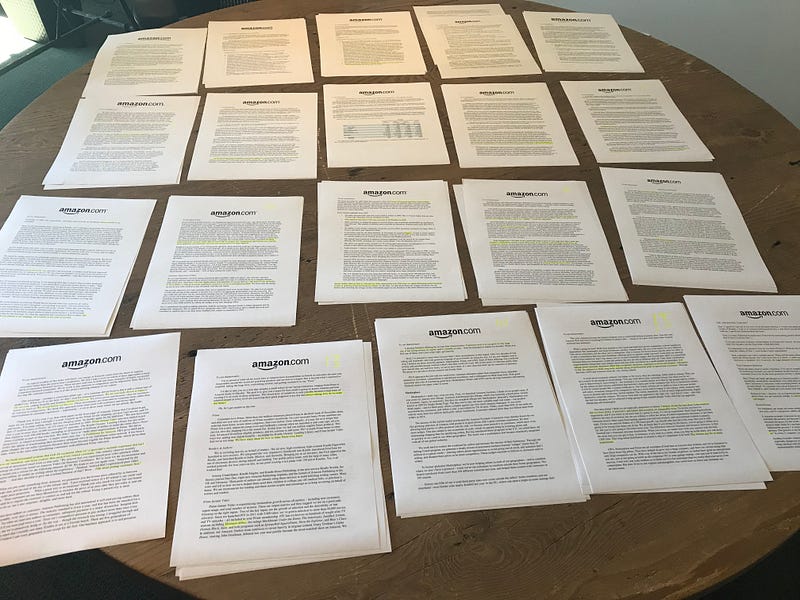
A new mentor of mine suggested I read Jeff Bezos’ Letter to Shareholders to refine my thoughts around building a career and a business.
So I read them all dating back to 1997 and here are my takeaways:
Despite memes (below) to the contrarian, the core operating principles of Amazon hasn’t changed much if at all since the company went public in 1997.
(more…)
At #chromedevsummit with @goldsounds. He’ll be speaking later about PWAs and #WordPress via #Jetpack
Posted on Instagram 12:32 pm, October 23, 2017 jQuery(document).ready(function(){ var gmap_m05762764a86af7c695fe8d385ee0385c = { positions : { 440 : new google.maps.LatLng( ‘37.784916242722’, ‘-122.40201715675’ ) }, bounds : new google.maps.LatLngBounds(), // empty for now, we’ll dynamically extend it later map : new google.maps.Map( document.getElementById( ‘gmap_m05762764a86af7c695fe8d385ee0385c’ ), { mapTypeId: google.maps.MapTypeId.ROADMAP, center: new google.maps.LatLng( 0, 0 ), zoom: 16 // Seems to be a good zoom for a single point } ), markers : {}, }; // end of gmap // Extend the bounds of interest based on our positions for ( var m in gmap_m05762764a86af7c695fe8d385ee0385c.positions ) { gmap_m05762764a86af7c695fe8d385ee0385c.bounds.extend( gmap_m05762764a86af7c695fe8d385ee0385c.positions[m] ); } // Render markers for ( var m in gmap_m05762764a86af7c695fe8d385ee0385c.positions ) { gmap_m05762764a86af7c695fe8d385ee0385c.markers[m] = new google.maps.Marker( { clickable: true, map : gmap_m05762764a86af7c695fe8d385ee0385c.map, position : gmap_m05762764a86af7c695fe8d385ee0385c.positions[m] } ); } // Redraw map to fit our new marker-based bounds gmap_m05762764a86af7c695fe8d385ee0385c.map.setCenter( gmap_m05762764a86af7c695fe8d385ee0385c.positions[440] ); });
Checked in at Isa Restaurant .
37.8001093-122.4377012
Checked in at San Francisco International Airport (SFO) .
Oh Hai, San Francisco! — with erika
37.6173044-122.3853406
Robert Scoble and Me – Quinn Norton – Medium

Foo Camp, the original unconference thrown by O’Reilly every year, is one of my favorite events in the technology world. In many ways, it’s often felt like one of the safest — it welcomes crazy ideas, breaks down social barriers, starts cross disciplinary conversations. Their format encourages people to contribute to sessions, or leave them, not if they’re angry, but just if they’re not getting much out of it or have much to contribute. People bounce around the space and ideas and conversations, and so many of the normal social distances break down into collaboration. This format is creative, and gave me access to both people and ideas that helped me shape my work and get it in front of a wider audience.
(more…)
@akires and I turned one of our home grown pumpkins into roasted chipotle seeds and delicious bread. #winning
Posted on Instagram 8:15 pm, October 14, 2017


Checked in at Rivers And Roads Coffee .
Back again and this place is hoppin — with erika
39.764749-104.956478

Checked in at Taquitos Jalisco .
And a little #burritofriday to round out the week.
39.763369-104.973137
The Coming Software Apocalypse
There were six hours during the night of April 10, 2014, when the entire population of Washington State had no 911 service. People who called for help got a busy signal. One Seattle woman dialed 911 at least 37 times while a stranger was trying to break into her house. When he finally crawled into her living room through a window, she picked up a kitchen knife. The man fled.
(more…)
This place is really cute, and seems to be a good spot for #cafeworking. Will try their food as well.
39.76464-104.95653
Posted on Instagram 12:20 pm, October 13, 2017 jQuery(document).ready(function(){ var gmap_m49bf99362a63b74961929ba691381850 = { positions : { 272 : new google.maps.LatLng( ‘39.76464’, ‘-104.95653’ ) }, bounds : new google.maps.LatLngBounds(), // empty for now, we’ll dynamically extend it later map : new google.maps.Map( document.getElementById( ‘gmap_m49bf99362a63b74961929ba691381850’ ), { mapTypeId: google.maps.MapTypeId.ROADMAP, center: new google.maps.LatLng( 0, 0 ), zoom: 16 // Seems to be a good zoom for a single point } ), markers : {}, }; // end of gmap // Extend the bounds of interest based on our positions for ( var m in gmap_m49bf99362a63b74961929ba691381850.positions ) { gmap_m49bf99362a63b74961929ba691381850.bounds.extend( gmap_m49bf99362a63b74961929ba691381850.positions[m] ); } // Render markers for ( var m in gmap_m49bf99362a63b74961929ba691381850.positions ) { gmap_m49bf99362a63b74961929ba691381850.markers[m] = new google.maps.Marker( { clickable: true, map : gmap_m49bf99362a63b74961929ba691381850.map, position : gmap_m49bf99362a63b74961929ba691381850.positions[m] } ); } // Redraw map to fit our new marker-based bounds gmap_m49bf99362a63b74961929ba691381850.map.setCenter( gmap_m49bf99362a63b74961929ba691381850.positions[272] ); });

Checked in at Rivers And Roads Coffee .
Need coffee to survive today, and wanted to check out this new place.
39.764749-104.956478
Many breakthrough technologies were hatched by hobbyists in garages and dorm rooms. Prominent examples include the PC, the web, blogs, and most open source software.
The fact that flip-flop wearing hobbyists spawn large industries is commonly viewed as an amusing eccentricity of the technology industry. But there is a reason why hobbies are so important.
(more…)Really cool library of visualizations with standardized colors to remove unnecessary visual variations. Love it.
Operational Ruthlessness, the key to fast growth startups

Since 2010, I’ve been religiously blogging about the ToutApp journey , but about 24 months ago I had to go on a blogging hiatus except for one small post about personal growth .
Over the past two years, ToutApp has grown from 7 people in size to 60+ people, delivered strong quarter over quarter growth, raised $3.3m and then $15m of venture capital from the best venture capital firm in the valley, and have built a crack team of badasses across our executive and management team .
(more…)


